
A Santa Ana wind event does not create a wildfire so much as it writes the terms under which one becomes catastrophic — turning a few acres of smoldering brush into a fast-moving front that can outrun fire crews, jump freeways, and consume a neighborhood before evacuation orders even finish going out.
Key Points
- Four named fires — Henderson, Bryson, Norte, and Peak — burned simultaneously across Southern California during an October Santa Ana wind event, with acreage ranging from roughly 43 to over 2,000 acres depending on the incident and timing of the report.
- The National Weather Service confirmed red-flag conditions and gusts up to 70 mph, the textbook ingredients for rapid Santa Ana-driven fire spread.
- Evacuation orders hit San Clemente, San Juan Capistrano, and part of Camp Pendleton, and a stretch of Interstate 5 was temporarily closed.
- Peer-reviewed research shows ignition frequency and wind speed, not temperature or drought alone, are the strongest predictors of how much acreage a Santa Ana fire ultimately burns.
- Scientists remain genuinely split on whether climate change is weakening Santa Ana winds overall or intensifying the specific “hot” Santa Ana events that do the most fire damage.
What Happened on the Ground
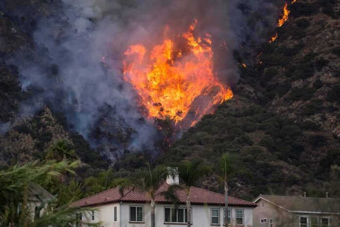
Within roughly 48 hours, Southern California fire agencies were managing four separate incidents under one shared meteorological assault. The Henderson fire, burning on and near the Camp Pendleton Marine Corps base in San Diego County, grew past 1,000 acres and eventually was reported above 2,000 acres with zero containment, prompting evacuation orders on the base and a partial closure of Interstate 5. The Norte fire ignited near San Clemente and San Juan Capistrano, destroying homes and expanding rapidly — contemporaneous reporting put it at roughly 250 acres before later updates pushed the figure past 400. The Bryson fire, in the Santa Monica Mountains above Malibu, grew from an initial 80 acres to nearly 200 by nightfall, forcing the evacuation of a county juvenile facility along with residential canyon communities. The Peak fire near Azusa was the outlier: crews stopped its forward progress at 43 acres within two hours, allowing officials to downgrade evacuation orders to warnings.
Los Angeles County’s emergency operations page documented a National Weather Service red-flag warning in effect and logged the Peak fire’s evacuation downgrade once containment lines held. That single data point illustrates something true of every fast-moving wind-driven fire: the acreage and containment numbers reported in any given hour are a snapshot of an evolving incident, not a final tally, and figures legitimately shift as crews gain or lose ground.
The Mechanism: Why Santa Ana Winds Are a Fire Accelerant, Not Just Weather
Santa Ana winds form when a high-pressure system parks itself over the Great Basin and a corresponding trough sets up to the south, compressing the atmosphere and forcing air to flow downslope from the interior desert toward the coast. As that air descends through mountain passes and canyons, it compresses adiabatically — warming and drying with every thousand feet it drops — and accelerates through terrain funnels the way water speeds up through a narrowed pipe. The National Weather Service defines the result as strong, warm, dry, downslope winds capable of exceeding 40 mph, conditions it explicitly states can “severely exacerbate brush or forest fires,” particularly when drought has already primed the vegetation. During this event, forecast products documented sustained winds in the 50–70 mph range and widespread critical fire-weather warnings across Southwest California — not a retrospective label applied after the fact, but a live forecast that agencies were acting on in real time.
It is worth being precise about what a red-flag warning actually means, because the term gets loosely used. It signals that conditions are ripe for extreme fire behavior if an ignition occurs — not that a fire is already burning or that the wind itself started one. The warning and the ignition are two separate facts, and conflating them muddies an otherwise sound public-safety tool.
How This Fits the Historical Pattern
Southern California effectively runs two distinct wildfire regimes rather than one. Summer fires are driven by heat and prolonged dryness; autumn and winter fires — the Santa Ana-driven variety — are driven primarily by wind, often igniting even when fuel moisture hasn’t reached its summer low. Research from USGS scientists examining decades of Santa Ana fire data found that the number of ignitions and wind speed together outweigh temperature and precipitation as predictors of how much area ultimately burns. That finding reframes the policy conversation: suppressing ignition sources — downed power lines, vehicle sparks, arson, equipment failure — may do more to limit catastrophic acreage than any effort to control the weather, because the weather conditions behind events like this one are, for practical purposes, uncontrollable and recurring.
Where Genuine Scientific Disagreement Remains
Climate researchers disagree, in good faith, on the trajectory of Santa Ana winds themselves. One body of work, including a UCLA-led analysis, finds that warming is already reducing the frequency of Santa Ana wind days overall, since the desert interior is heating faster than the coastal ocean, shrinking the pressure differential that drives the wind. A competing strand of research complicates that comfort: it finds that “hot” Santa Ana events — the subtype responsible for roughly 90 percent of large Santa Ana-driven wildfires historically — are not declining and may even be increasing, even as milder “cold” Santa Ana events become rarer. In practice, that means fewer total Santa Ana wind days could still coincide with the most dangerous individual events becoming more frequent or more intense, a distinction easily lost in any single headline about winds “weakening.”
Santa Ana winds fuel multiple Southern California wildfires pic.twitter.com/le5ZGtDAGj
— Inquirer (@inquirerdotnet) October 17, 2026
What It Means Going Forward
For residents, utilities, and emergency planners, the practical lesson repeats every fire season: a red-flag warning is an operational trigger, not background noise. Fire departments pre-position engines and water tenders in canyon and foothill zones before winds peak; utilities weigh public-safety power shutoffs against the inconvenience and risk of leaving lines energized in high wind; and evacuation planning increasingly assumes that any ignition during a Santa Ana event has the potential to become a multi-hundred-acre fire within hours, not days. The four fires that burned simultaneously in this episode — one contained quickly, three others growing fast — are not an anomaly but the expected shape of the risk this terrain and this wind pattern have always produced, and will keep producing as long as Southern California’s geography and its autumn weather remain what they are.
Sources:
fire.ca.gov, latimes.com, lacounty.gov, en.koreadaily.com, abc7.com, gfdl.noaa.gov, repository.library.noaa.gov, link.springer.com, science.org