
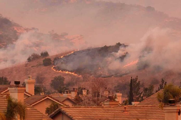
When thousands of people are ordered to leave their homes at once, it is not a communications glitch or media exaggeration; it is the visible tip of an emergency system straining to keep pace with fast-moving, wind‑driven fire in a landscape primed to burn.
At a Glance
- Spokane County issued multiple Level 3 “Go Now” evacuation orders as wind‑driven fires grew rapidly and threatened densely populated areas.
- Governor Bob Ferguson declared a statewide emergency and burn ban as part of a broader Washington wildfire crisis, with more than a dozen fires and hundreds of thousands of acres burning.
- Strong winds, very low humidity, and dry fuels under a rare “particularly dangerous situation” red‑flag warning drove extreme fire behavior and rapid expansion of evacuation zones.
- Emergency response involved multi‑agency fire operations, National Guard mobilization, and the opening of evacuation shelters for thousands of displaced residents.
- The Spokane fires sit inside a larger pattern: earlier, hotter, drier fire seasons in Washington, shaped by drought, fuel buildup, and climate‑driven shifts in regional risk.
How Spokane’s Wildfire Emergency Unfolded
From the standpoint of incident management, the Spokane wildfire emergency is best understood as a cluster of separate but overlapping fires—Old Trails, Upriver, Fairview, Cougar and others—whose impacts were experienced by residents as a single, escalating crisis. Local outlets and live feeds document how, over the course of a day, evacuation boundaries that began around specific ignition points expanded outward as wind and terrain pushed flames toward new neighborhoods. What started as a localized threat near Upriver Drive and Airway Heights became a county‑wide posture of “Go now, this may be your only notice.”
Fire growth was fast enough that numbers reported to the public changed within hours. The Old Trails Fire, burning northwest of Airway Heights near Euclid and Trails roads, was reported at roughly 1,200 acres in the early afternoon based on Department of Natural Resources (DNR) figures, then at more than 2,000 acres in the evening update as wind drove the fire through tree crowns. Similar dynamics played out elsewhere in eastern Washington; state briefings described individual fires expanding by thousands of acres in less than a day. That level of volatility is precisely why evacuation triggers were pushed to their highest level for broad zones around northwest and north Spokane.
For people living inside those maps, the emergency did not feel abstract. Residents described leaving in minutes, sometimes without pets, heading toward designated shelters such as the Spokane Falls Community College gym with cars packed with whatever they could grab. North‑south routes like US 395 and east‑west arterials like Francis Avenue became congested evacuation corridors, with law enforcement working to keep them clear even as smoke reduced visibility. The fact pattern is consistent across multiple independent reports: thousands of residents were in motion at once, under formal orders to get out.
What Level 3 “Go Now” Really Means
Spokane County, like much of Washington, uses a three‑tier evacuation protocol: Level 1 (be ready), Level 2 (be set), and Level 3 (go now). In this incident, county alerts and agency posts repeatedly invoked Level 3 for areas near Upriver Drive, Beacon Hill, Airway Heights, Keeney Road, Washington Road, and zones north of Francis Avenue. The language was unambiguous: residents were told they “must leave now due to the life‑threatening conditions in your area,” with warnings that this might be their only notice.
Those orders are not merely advisory. Level 3 is designed for situations where fire behavior, weather, and access constraints make sheltering in place unsafe both for residents and for firefighters. In Spokane, deputies and city police were actively directing traffic away from key choke points, closing roads, and working to prevent spontaneous congestion that could trap people in harm’s way. By the time the governor’s emergency declaration was in place, multiple communities around Spokane—particularly to the northwest—were under some combination of Level 2 and Level 3 orders, with thousands of structures inside the evacuation footprint.
The structure threat was not hypothetical. NBC and local stations cited county estimates that more than 2,300 primary and secondary structures lay within evacuation areas in the Old Trails incident alone, and KREM’s DNR source made clear he suspected some homes had already been impacted. On social and broadcast video, viewers could watch walls of flame and thick black smoke approaching residential areas and public facilities. In that context, the insistence on immediate evacuation is not over‑reaction; it is the system functioning as intended under high‑end fire weather.
Winds, Drought and a Dangerous Red‑Flag Setup
The operational drivers of the Spokane fires match a pattern that fire managers in Washington have been warning about for several seasons: hot temperatures, low humidity, very dry fuels, and strong winds arriving together. The National Weather Service’s Spokane office did not just issue a routine red‑flag warning; forecasters labeled it a “particularly dangerous situation,” a designation reserved for episodes where the combination of wind and dryness is expected to produce extreme fire behavior. According to disaster tracking platforms and state briefings, gusts in eastern Washington reached 35–45 mph as the fires were burning.
Those winds were moving across a landscape that was already primed. Washington’s winter snowpack had been poor, spring was unusually warm, and summer arrived hot and dry, eroding the region’s water reserves and leaving grasses, shrubs and forests desiccated earlier than normal. State climatology work and local reporting around Spokane describe fuel conditions as “ripe for any sort of ignition,” with rainfall at Spokane International Airport running less than half of normal in the months leading into fire season. Under that kind of deficit, a dry cold front like the one described in Spokane County’s earlier disaster documentation becomes a catalyst—lowering humidity, increasing winds, and converting latent fuel stress into active fire spread.
At the statewide scale, the situation around Spokane was just one node in a larger emergency. The Department of Natural Resources has tracked more than 1,000 fires in Washington in recent seasons, with hundreds of thousands of acres burned. In the period when Spokane’s evacuations were ordered, state officials referenced more than a dozen large fires burning across eastern Washington, with total acreage exceeding 200,000 and requiring thousands of firefighters. National‑level fire risk outlooks had already flagged eastern Washington for above‑normal fire potential through the heart of summer. In short, the severe conditions that made Spokane’s fires so dangerous were known in advance; the red‑flag warning and emergency declaration were responses to that forecast colliding with actual ignitions.
Governor Ferguson’s Emergency Declaration and Statewide Response
When Governor Bob Ferguson declared a statewide emergency and burn ban, he was not acting solely on Spokane’s behalf. His order came as wildfires across more than 100,000 hectares (roughly 250,000 acres) of Washington forced widespread evacuations and power outages, particularly in the Spokane area and other eastern counties. State Commissioner of Public Lands Dave Upthegrove summarized the challenge in a virtual briefing: more than a dozen fires, about 4,000 personnel engaged, and a fire season already on track to be one of the worst on record.
The emergency declaration unlocked additional tools. Ferguson authorized state mobilization, including deployment of National Guard firefighters to support local departments on incidents like Old Trails. He also issued a statewide burn ban meant to reduce the risk of new human‑caused ignitions during a period when existing fires were already stretching resources thin. The Old Trails fire was explicitly cited in both national and regional coverage as one of the triggers for these actions, given its rapid growth and proximity to Spokane’s urban fringe.
From the resident’s perspective, the distinction between state and county authority is less important than the practical effects: more crews on the line, more aircraft in the air, and tighter restrictions on activities that spark new fires. But the declaration also signals something deeper about the trajectory of Washington’s fire seasons—the point at which wildfires are no longer treated as isolated events but as a systemic, statewide hazard requiring coordinated response.
BREAKING: Massive wildfires have scorched more than 250,000 acres across Washington state, forcing widespread evacuations and leaving around 60,000 people without power.
The largest blaze near Spokane has burned about 3,000 acres and is threatening roughly 4,000 structures. pic.twitter.com/Pzsml8J7Sj
— Warzone Report (@Warzonereports) August 2, 2026
Why Washington’s Wildfires Are Worsening
To ask whether Washington’s wildfires are “getting worse” is to ask several questions at once: about area burned, about fire behavior, about human exposure. National fire science work shows that while the absolute number of ignitions has not risen dramatically over the past few decades, the severity, size and complexity of western fires have. In Washington, the Department of Ecology and regional climate projects point to a clear driver: hotter, drier summers, more extreme fire danger days, and longer windows when fuels are receptive to ignition.
Local data around Spokane align with that macro picture. Climate‑risk assessments estimate that roughly 60 percent of buildings in Spokane are exposed to significant wildfire risk, a figure driven by the city’s interface with surrounding forest and grasslands. Projections for the region forecast more “Extreme Fire Danger Days” as the century progresses, with smoke and health impacts likely to rise in tandem. State drought declarations covering all watersheds, issued after years of precipitation deficits and low snowpack, have formalized what residents already feel: fire season is longer, more intense, and more likely to intersect directly with where people live.
Fuel conditions matter just as much as climate. Decades of suppression have allowed continuous layers of brush, small trees and grass to accumulate, creating what foresters describe as “ladder fuels” that help fire climb into the canopy. Combined with expanding residential development into fire‑prone areas, those fuels turn ordinary summer ignitions into incidents like Old Trails: crown fires, rapid spread, thousands of structures within the evacuation footprint. In that sense, the Spokane emergency is neither an anomaly nor merely “bad luck”; it is an expression of a system that has grown more fragile over time.
Navigating a Fast‑Moving Fire Crisis
One understandable source of public confusion in Spokane was the sheer speed at which information changed. Acreage estimates were revised throughout the day. Evacuation zones expanded, then in some cases were later downgraded as fire edges shifted or containment improved. Some early reports of structure loss were phrased as suspicions rather than confirmed facts, pending damage assessments. This is a predictable feature of live emergency coverage, not evidence of fabrication or overstatement; incident commanders must act on the best available information in real time and then refine the record later.
That dynamic places a premium on two behaviors. First, residents must treat official alerts—text messages, reverse 911 calls, county websites—as authoritative even if details such as exact acreage or road closures are later updated. Second, agencies need to communicate as clearly as possible about what is provisional (for example, “unconfirmed reports” of structures burning) versus what is established (for example, “Level 3, leave now”). Spokane’s emergency management systems, both county and city, were heavily used during these fires, and interviews with evacuees show that those who were signed up for alerts received timely instructions that shaped their decisions.
There will be time, after the smoke clears, for forensic reconstruction: mapping ignition points, calculating final acreage, tallying structure losses, and reviewing dispatch logs. The evidence currently available—across broadcast, print, and official channels—already supports a clear core picture: thousands of people around Spokane were ordered to evacuate under life‑threatening fire conditions, in a state whose broader wildfire risk has been rising and whose emergency institutions are now treating fire season as a recurring statewide crisis rather than a series of isolated local events.
Sources:
insiderpaper.com, khq.com, nbcnews.com, katu.com, timesnownews.com, youtube.com, facebook.com, fox13seattle.com, my.spokanecity.org, krem.com, content.govdelivery.com, kuow.org, kitsapsun.com, vanguardngr.com, en.wikipedia.org, climatecheck.com, spokaneclimateproject.org, rangemedia.co, washingtonexaminer.com