
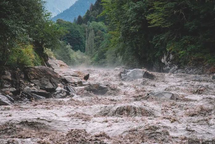
The defining truth of this disaster is mechanical, not mysterious: a high-mountain rock–ice avalanche cascaded into a Himalayan valley, rapidly converting stored cryosphere mass into a destructive debris-laden flood that tore through settlements and infrastructure—exactly the kind of compound event scientists have warned will grow more frequent as the region warms.
At a Glance
- Police in Nepal report a mounting death toll—into the hundreds—as recovery continues after a catastrophic flash flood near the Nepal–Tibet border.
- Preliminary satellite and seismic assessments point to an ice avalanche from a glacier as the trigger, not a conventional rainfall flood.
- The event fits a broader Himalayan pattern in which rock–ice mass movements initiate glacial lake outburst–like floods, with large, fast hydrographs and heavy debris loads.
- Climate-driven glacier retreat and expanding glacial lakes, combined with roads, hydropower, and border trade corridors placed in narrow valleys, amplify exposure and losses.
What Happened: A Cascade That Became a Flood
Rescue and recovery teams in Nepal have worked amid wreckage left by a sudden, high-energy flood that surged down from the high country toward settlements and project sites along key border corridors. Police counts have climbed into the hundreds as bodies are recovered, with many still unaccounted for—a bleak arithmetic familiar to mountain disaster responders when a nighttime or early-morning surge outruns warning and mobility. Early reporting coalesced around a non-monsoonal trigger: a failure in the cryosphere rather than a standard storm flood, with on-the-ground damage signatures—washed-out bridge abutments, scoured channels, and stacked woody debris—consistent with a highly turbulent, sediment-rich surge.
The strongest early technical signal comes from remote sensing and seismology. A preliminary read of satellite imagery indicates a large ice avalanche initiated the sequence, entraining rock and snow and converting gravitational potential into a fast-moving mass that injected extraordinary momentum into the valley floor. Seismic analysts correlated the timing: an apparent “tremor” recorded near the onset was not a tectonic earthquake but the signature of collapsing rock and ice—an impact large enough to register regionally. This is not speculation dressed up as physics; it is the pattern seen in other Himalayan compound disasters where a rock–ice collapse either overran a glacier tongue, struck a proglacial lake, or dammed and then catastrophically released river flow.
How Such Events Unfold: From Slope Failure to Downstream Catastrophe
In cold high mountains, water is stored not only as lake volume but as perched mass in cliffs, seracs, and permafrost-laced talus. When an avalanche of rock and ice drops thousands of feet, two dangerous transformations occur. First, it pulverizes into a mobile mixture that can travel long distances as a debris flow. Second, if it impacts a glacial lake—common at the toes of retreating glaciers—it displaces and overtops water, sending a surge down-valley. Even in the absence of a sizable lake, the collapsing mass can bulldoze channel banks, scour bed material, and entrain water and sediment, rapidly amplifying discharge. The resulting wave carries boulders, trees, and infrastructure fragments; it moves with a front that can feel like a wall. Hydropower intakes, unstable road cuts, and riverbank settlements sit directly in its path.
Scientists categorize the most damaging of these as glacial lake outburst floods, or GLOFs—rapid drainages of lakes impounded by moraines (unconsolidated glacial debris), ice, or bedrock. Triggers vary: icefalls, rockslides, snowfall avalanches, or even small earthquakes. In many recent Himalayan cases, a mass movement is the spark; the lake and valley geometry then dictate how large the surge becomes. The expected discharges are not modest: modeling work shows that a 100‑year GLOF in the eastern Himalaya can rival downstream monsoon rivers in flow rate, but on far shorter time scales and with dramatically higher sediment and debris loads.
Evidence for the Trigger: What We Can Say with Confidence
Multiple independent reporting streams align on an avalanche origin. A University of Dundee glaciologist, analyzing early imagery, flagged a sizable ice avalanche as the initiating failure. Regional outlets citing Planet Labs imagery described a lower-glacier collapse consistent with this diagnosis. Meanwhile, seismological parsing by U.S. analysts matched the timing of the “quake” to a mass-impact signal, not tectonics—effectively ruling out an earthquake as the primary cause even if small ground motions might have contributed to slope instability. Kathmandu-based experts at the International Centre for Integrated Mountain Development (ICIMOD) likewise identified an avalanche from a glacier as the likely proximate trigger, matching both the physics and the field reports.
As in all fast-moving mountain disasters, some early details evolved as better data arrived; that does not blunt the central conclusion. The storyline that remains robust is avalanche-to-flood, with no credible countervailing mechanism emerging from agencies or instrument records. Descriptions from responders—remote communities cut off, bridges gone, project sites compromised—fit the footprint of a debris-rich surge rather than a slow-rising monsoon swell.
Why This Keeps Happening: Warming, Water, and Where We Build
The Hindu Kush–Himalaya is not a static landscape; it is a living cryosphere under thermal stress. Glaciers have been losing mass for decades, and in the modern record, negative balances dominate—retreat exposes oversteepened headwalls and leaves behind lakes at glacier margins that grow as ice thins. Syntheses across the region document hundreds of known GLOFs and a thickening inventory of potentially dangerous lakes. ICIMOD and allied researchers have mapped how retreat, permafrost thaw, and geomorphic oversteepening elevate the odds that a discrete slope failure—rock, ice, or both—will set off a chain reaction.
At the same time, exposure has marched upward. Roads and trade routes push into narrow valleys; hydropower diversions and dams sit near steep tributary confluences; hospitality and logistics clusters sprout around border posts and trekking gateways. None of that is inherently reckless—mountain economies need connectivity and power—but the siting choices often reflect river normalcy, not rare but foreseeable surge extremes. When an outburst freighted with boulders arrives, design freeboard and channel training works built for monsoon hydrographs can fail abruptly.
“With record summer heatwaves and ‘weather whiplash’ events, global warming is fast becoming normalised. Now shocking video has emerged of unsurvivable flash floods in Nepal and Tibet, probably caused by a melting Himalayan glacier. Geologists have been warning about this for… pic.twitter.com/JPu7pvaL3h
— The Socialist Party (@OfficialSPGB) August 27, 2026
What Effective Risk Reduction Looks Like in the High Himalaya
Three disciplines must work together to lower the casualty count the next time a slope gives way. First, monitoring: sustained satellite tasking on known unstable glaciers and lakes; ground-based radar or infrasound to catch large rock–ice detachments; automated river gauges with telemetry that survives first-impact debris. Second, zoning and design: honest flood mapping that models surge heights and boulder mobility, then enforces setbacks for housing and places critical infrastructure above dynamic channel margins. Hydropower intakes, in particular, need sacrificial structures, debris bypasses, and emergency drawdown plans that anticipate sediment slugs, not only high water.
Third, cross-border operations: when source areas straddle the Nepal–Tibet frontier, preparedness cannot stop at a customs gate. Shared watch lists of unstable slopes and lakes, agreed alert thresholds, and standardized message formats between national disaster agencies translate minutes into saved lives. The region has learned these lessons in Sikkim, Chamoli, and now along the Bhote Koshi system; codifying them into everyday practice is the difference between episodic heroics and systemic resilience.
Reading This Event in the Long Arc
Disasters do not “prove” climate change any more than a single heat wave proves summer; the chain of evidence runs through glacier mass-balance records, lake-inventory growth, and the physics of slope failure under warming. On those measures, the diagnosis is settled: a warmer Himalaya is a more failure-prone Himalaya, with more water impounded behind weaker dams and more oversteepened headwalls waiting for a trigger. The Nepal border flood belongs to that lineage. The proximate cause was an avalanche; the enabling conditions were built over decades.
Grief and logistics dominate the present: identifying the dead, supporting survivors, restoring roads and power. The next season will bring reconstruction decisions. If those decisions embed what the evidence already shows—avalanche-to-flood chains are recurring, fast, and devastating—then the memory of this event can bend future losses downward. Ignore it, and the map of risk will draw itself again, one steep valley at a time.
Sources:
nytimes.com, npr.org, thestar.com.my, reuters.com, bbc.com, indiatoday.in, mhewc.org, lib.icimod.org, icimod.org, pnas.org, scribd.com, unisdr.org